
The recording of the my AusIMM webinar is still not accessible. I’ll let you know when it is.
17. South America and Africa trans-Atlantic seismic tomography traverse.
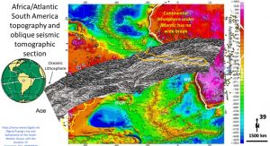
This figure is an oblique seismic tomographic section from almost Fiji in the Pacific, right through central South America to central northern Africa (Ballmer et al., 2015). It can be seen that there is a thin ~30 km thick oceanic crust in the Pacific but from the Andes across to Africa there is a continental lithosphere ranging from 1,000 kilometres thick where it is subducted under South America to 600 km thick across the Atlantic and Africa.
The seismic tomography section has been overlain to show the moderately dipping structure (50°E) of the Mid-Atlantic ridge and the continuous >500 km thick lithosphere from western South America to the central Sahara in Africa.
When we were looking at Africa there was a section across Africa that continued on from this section right up to the Arabian shield region and the 600 km thick lithosphere continued that whole distance. The only breaks were the incipient 400 km deep East African and the Central Sahara rifts (Watchorn AusIMM talk on Africa 2020, link – https://vimeo.com/464013825/1ed4a0c752 ).
The existence of the Late Heavy Bombardment rings across this whole area (from previous figures) shows that this area has not separated more than the small amount visible (white) in the mid-Atlantic since 4,000 million years ago.
What does this new structural geology evidence of only a narrow Atlantic ridge mean for our understanding of Plate Tectonics????
18. Changes in the paradigm of the mechanism of Plate Tectonics
My hypothesis of how Plate Tectonics works is that the lithosphere formed >4 billion years ago, was continuous and at least 800 kilometres deep.
This original lithosphere had rigid structures to the core (still has) and only split and separated very slowly. As it separated it should have allowed more movement and thus the recent movement should be the fastest it’s ever moved. If this is correct then the current concept of a world encircling plastic mantle, thin lithosphere and crust needs revising.
Hypothesizing about the early formation of earth is always interesting and instructive.
- The interstellar dust would have been at about -100°C – very cold.
- Earth Formed very quickly supposedly in 5 million years (REF ) through gravity suggesting the iron core may have been partially there from the beginning (at – 100°C) causing strong gravity.
- As soon as Earth formed it was covered by water – cold (http://www.geologypage.com/2020/09/meteorite-study-suggests-earth-may-have-been-wet-since-it-formed.html). Why and how?
- Earth was bombarded by planet Theai at ~4.5 billion years ago and spalled off the moon (University of Munster 2019).
- Planet Theai originated in the wet, carbonaceous outer solar system and thus brought water and life to ‘earth. (University of Munster 2019)
- Within 150 million years life formed under this water – still cold.
- This life continued right through the Late Heavy Bombardment from 4.1 – 3.8 billion years ago – under water – still cold and passive – relatively speaking.
- The Earth’s interior has subsequently heated up from radioactivity and compaction.
- The cool crust and oceans form a good insulation to stop heat escaping and so the interior has probably got hotter over the last 4 billion years rather than cooler.
Conclusion – that early Earth was no warmer than it is now and thus was NOT the hot, thin crusted planet invoked by the current Plate Tectonic hypothesis. This entirely changes our paradigms of how Plate Tectonics could operate.
The current Plate Tectonics hypothesis is based on fuzzy details of internal Earth with no hard structural geology. It is useful to remember that no-one has seen the earth in such ultra detail before and this changes what we can see and thus how we interpret the earth…. that’s the scientific method!
Comments please….
We will next be examining – Global seismic tomography at 200 km and 2850 km depth – so stay tuned! Share with those that devour the cutting edge of geoscience – always a danger zone …..
Cheers
Bob