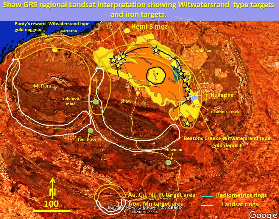
Figure 32 above. Shaw and Mt Flora ring structures, Witwatersrand type targets.
There has been a lot of alluvial gold found on the unconformable Fortescue basin boundary recently. Why and where does it come from?
The above figure illustrates Pilbara exploration targeting using South Africa’s Witwatersrand basin placed as a template on the Pilbara craton/Fortescue Group boundary. This may explain the nuggety, conglomerate associated gold in the Fortescue which originated in the Archaean and is transported to the younger basin.
There is a strong unconformable boundary between the greater than 3 billion years old Archaean cratonic basement, and the 2.6 billion year old Fortescue group sedimentary basin deposited on top.
I overlaid the Witwatersrand basin onto the edge of the Fortescue basin as they are of similar scale.
The newly discovered gold mines and deposits following the unconformable contact on the Shaw ring structure’s northern margin (orange crescent) have similar characteristics to the alluvial/eluvial gold deposits of the Witwatersrand, except for scale 🙂 .
The Mount Flora ring structure to the west has a similar northern unconformable contact which would also be worth exploring for gold (orange crescent).
The white crescents on the southern side of the Mount Flora and Shaw ring structures would also be good for gold except that they are covered by quite a few kilometres of Fortescue and Hamersley Basin sediments. However, large volumes of fluid will be coming through these particular arcs (white crescents) and so they would be worth exploring for iron mineralisation in the right environment and also for all the minerals, such as copper and MVT deposits such as silver, lead and zinc whose mineralising fluids can travel, from beneath, through great thicknesses of sediment. Although not right on these arcs the Paulsons, Abra and Karlawinda mines might be examples?
Targeting for all minerals would involve looking where large cross cutting structures cut these ring structures and then honing in on the high heat flow areas represented by the structures at 300 km shown in figure 29.
All of the sedimentary type targeting techniques used in the Witwatersrand could also be used in the Fortescue Basin.

The outlines of the Shaw and Mt Flora rings from radiometrics and Landsat are shown. The larger Pilbara craton appears to encompass these rings but is most likely formed by the large Ring X seen on the seismic tomography at 300 km depth in figure 28.
It is an interesting plan! These rings are VERY prominent in the public Landsat and radiometrics plans, without any enhancement. Look for yourself! Yet nobody sees them and they have never been reported or researched except by myself??
This is very strange and perhaps shows the bias of the current geoscience industry!