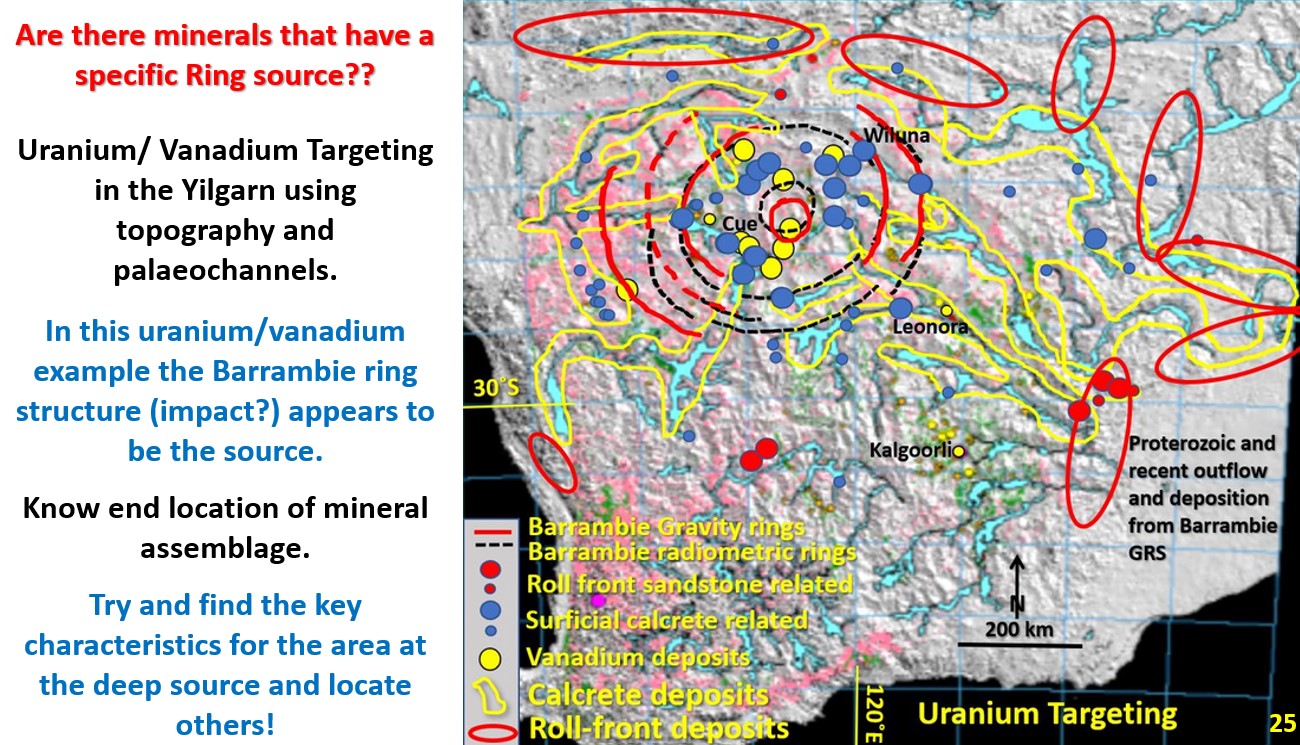
Figure 25 above. Barrambie Ring uranium vanadium occurrence and exploration targeting.
This figure shows the 500 km diameter Barrambie ring structure near Sandstone. Nearly all the Yilgarn Craton’s vanadium and uranium deposits lie within the medium ring of this structure. See post https://staging.geotreks.com.au/wp/work/giant-ring-structures/uranium-vanadium-yilgarn-barrambie-grs/ for more details.
Why is uranium only associated with the Barrambie Giant Ring Structure (GRS) and not the other GRS? The Yilgarn GRS all have similar morphology and structure. It is suggested that the Barrambie GRS impact area, or the impacting bolide itself, was initially more uranium and vanadium rich.
While I believe that most mineralisation has emanated from the Outer Core there may be areas where surface activity, including meteorite impacts, have provided minerals that have formed economic deposits.
If these minerals had come from the Outer Core, then these minerals should not just be in this tight area.
Thus, it is suggested that the Barrambie impactor may have provided the vanadium and uranium enrichment.
Are radiometrics associated with specific rings defining metallogenic provinces?

The area inside the Wiluna ring of the Barrambie GRS is a more intense green than the surrounding area. A green radiometric signature is composed of yellow (thorium) and blue (uranium). It has been suggested by recent external research that impacts can be classified by their different original meteorite/bolide composition.
Can Yilgarn impacts may be classified by metallogeny on this radiometric basis?
The Yilgarn GRS have conspicuous radiometric signatures; Watchorn and Gindalbie are pink/purple/reddish. Is this because of K alteration, which is intimately associated with gold mineralisation? Cauden, Barrambie, Malgar and Miloura have more brown/yellow/greenish Is this because of a higher concentration of thorium – which is associated with iron (vanadium?) mineralisation? Norseman, Yamarna suite and Paynes have a more blueish/purple radiometric signature which may mean they are more uranium enriched.
It is suggested that this observation may form the basis for using the GRS as a basis for metallogenic provinces and that this should lead to targeting for the specific associated minerals within these areas. A brief investigation of the primary mineral mined in each area suggests that the radiometric signature is defining the main mineral found in each GRS.
See post on Gindalbie ring structure. https://staging.geotreks.com.au/wp/work/giant-ring-structures/gindalbie-giant-ring-structure/
Radiometric characteristics are already used extensively for local targeting. It is suggested that they can also be used for regional targeting.